Storm Tra Mi keeps changing direction, new storms are about to form, so who names them?
1 | 1 Discuss | Share
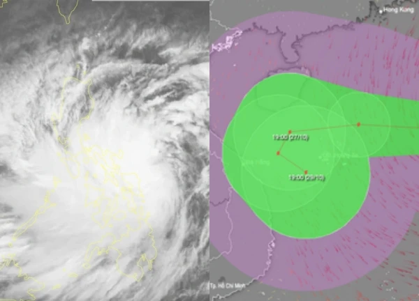
According to the National Center for Hydro-Meteorological Forecasting, around noon tomorrow (October 27), storm No. 6 will enter the sea off the Central Central region. The Deputy Minister of Agriculture and Rural Development emphasized that this is a very large storm.
According to the National Center for Hydro-Meteorological Forecasting, at 1:00 p.m. on October 26, the center of storm Tra Mi was at about 17.0 degrees north latitude; 112.2 degrees east longitude, in the sea north of Hoang Sa archipelago, about 440km east-northeast of Da Nang. The strongest wind near the center of the storm is level 11-12 (103-133km/h), gusting to level 15. The storm is moving in a West-Southwest direction, at a speed of about 20km/h.
At 1 p.m. on October 27, the center of the storm was located at approximately 16.6 degrees north latitude; 108.5 degrees east longitude, in the sea off the coast of Central Central Vietnam. The strongest wind near the center of the storm was level 10-11, gusting to level 14. The storm moved in a West-Southwest direction at a speed of 15-20 km/hour.
At 1:00 p.m. on October 28, the center of the storm was at about 15.9 degrees north latitude; 109.2 degrees east longitude, in the coastal waters of the Central Central provinces. The strongest wind near the center of the storm was level 9, gusting to level 11. The storm moved west-southwest then east, at a speed of about 5km/hour.
At 1 p.m. on October 29, the center of the storm was at about 15.8 degrees north latitude; 110.4 degrees east longitude, over the sea of the Central Central provinces. The strongest wind near the center of the storm was level 8, gusting to level 10. The storm moved east at a speed of 5-10 km/hour.
From the next 72 to 120 hours, storm Tra Mi will move mainly eastward at 5-10km per hour, and its intensity will continue to weaken. Due to the storm's influence, the sea area west of the northern East Sea will have strong winds of level 8-9, the area near the storm's center will have winds of level 10-12 (89-133km/h), gusting to level 15, waves 5-7m high, the area near the storm's center will have waves of 7-9m; the sea will be very rough.
The sea area of provinces from Quang Binh to Quang Ngai (including Con Co Island, Cu Lao Cham, Ly Son) has strong winds of level 6-7, then increasing to level 8-9, near the storm's eye level 10-11, gusting to level 14, waves 3-5m high, near the storm's eye 5-7m; the sea is very rough.
Warning: From the morning of October 27, coastal areas from Quang Binh to Quang Nam provinces are likely to experience storm surges of 0.4-0.6m high. Ships and boats operating in the above-mentioned dangerous areas (especially in the Hoang Sa island district), coastal areas from Quang Binh to Quang Ngai are likely to be affected by storms, whirlwinds, strong winds, and large waves.
There is a high risk of landslides on coastal dykes and seawalls in the provinces from Quang Tri to Quang Nam due to the impact of big waves and storm surges. On the mainland, coastal areas from Quang Binh to Quang Ngai will have winds gradually increasing to level 6-7, near the storm center to level 8-9, gusting to level 12.
From the evening and night of October 26 to the night of October 28, in the area from Quang Binh to Quang Ngai, there will be heavy to very heavy rain with total rainfall ranging from 300-500mm, locally over 700mm. Warning of the risk of local heavy rain. The areas of Ha Tinh, Binh Dinh and the Northern Central Highlands will have heavy rain, locally very heavy rain with total rainfall ranging from 100-200mm, locally over 300mm.
Previously, according to the Natural Resources and Environment newspaper, the Ministry of Agriculture and Rural Development held a meeting to deploy responses to storm Tra Mi. This is the first storm to affect the Central region in 2024 and according to the assessment of the authorities, the storm will be strongest when it is at sea, circulating and causing heavy rain in the provinces of Quang Tri - Quang Ngai, leading to the risk of floods, inundation, and landslides.
Sharing with Nguoi Lao Dong newspaper, Deputy Minister of Agriculture and Rural Development Nguyen Hoang Hiep emphasized that this is a very strong storm. From the beginning of the year, there were forecasts of major floods in the year of Giap Thin, recently storm No. 3 caused terrible floods after 70 years in the North. With the current scenario, "we are very worried about another flood occurring in the Central region like in 2020" - Mr. Hiep warned.
Storm Trami heads straight for the Central region, Quang Ninh to Binh Thuan proactively respond  Hướng Dương18:33:03 22/10/2024According to the National Center for Hydro-Meteorological Forecasting, storm Trami with gusts of level 14 and waves up to 8 meters high is moving towards the East Sea and is likely to directly affect Vietnam's waters.

1 | 1 Discuss | Share
8 | 1 Discuss | Share

1 | 1 Discuss | Share

1 | 1 Discuss | Share

1 | 1 Discuss | Share

1 | 1 Discuss | Share

5 | 1 Discuss | Share

1 | 1 Discuss | Share

2 | 1 Discuss | Share

4 | 1 Discuss | Share

1 | 1 Discuss | Share

6 | 1 Discuss | Share




3 | 1 Discuss | Report