Typhoon Wipha is forecast to have a path quite similar to Super Typhoon Yagi in 2024, and at the same time, it will encounter many favorable conditions to strengthen. Therefore, the National Center for Hydro-Meteorological Forecasting recommends that there should be a plan to prevent strong storms.
At 1:00 p.m. on July 18, the storm center was in the sea northeast of Luzon Island, Philippines , with the strongest winds near the storm center at level 8-9 (62-88 km/h), gusting to level 11. In the previous hours, the storm moved very quickly in a northwest direction at a speed of about 30 km/h.
According to Mr. Mai Van Khiem, Director of the National Center for Hydro-Meteorological Forecasting, when entering the East Sea, storm Wipha will encounter many favorable conditions to become a very strong storm such as high sea surface conditions, large ocean heat, and weak wind shear. Therefore, when entering the East Sea on the morning of July 19, the storm can quickly increase in intensity.
Regarding the storm's path, according to Mr. Khiem, international stations currently do not have a high level of consensus. When the storm enters the East Sea, the meteorological agency will have more data to make more accurate assessments.
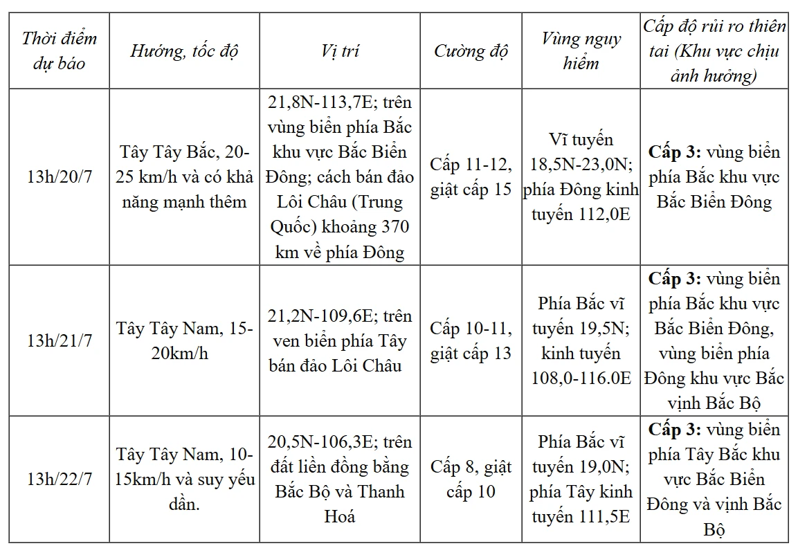
According to the assessment of the National Center for Hydro-Meteorological Forecasting on the afternoon of July 18, when entering the East Sea, the storm will move very quickly, reaching its strongest intensity when entering the eastern area of the Leizhou peninsula with an intensity of about level 12, gusting to level 15.
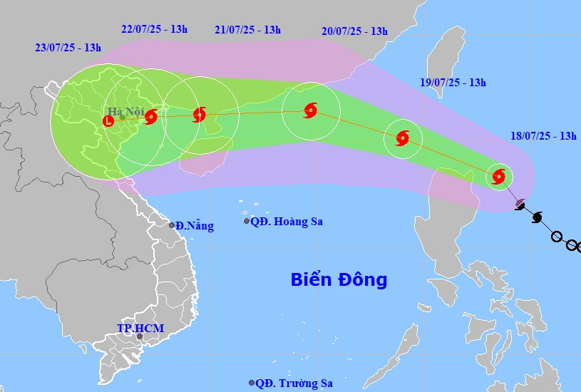
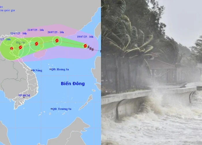
It is forecasted that after entering the Leizhou Peninsula, on the morning of July 21, Typhoon Wipha will begin to move into the Gulf of Tonkin. From around the evening and night of July 21, the storm may begin to affect the mainland of our country with the affected area extending from Quang Ninh to Nghe An. The storm may also affect later, from July 22.

According to Mr. Mai Van Khiem, the scenario of the storm making landfall in the North of our country is quite high, which can cause widespread heavy rain. It is forecasted that from the afternoon of July 20, the storm clouds on the western edge of the storm have started causing rain.
From July 21-24, the storm may cause widespread heavy rain in the northern provinces and Thanh Hoa to Ha Tinh. Rainfall is forecast to be from 200-350mm, with some places over 600mm. However, this is an initial preliminary assessment and is not yet highly reliable. Rainfall also depends on the direction of the storm. The National Center for Hydro-Meteorological Forecasting said it will update specifically in the emergency storm bulletin issued on July 20.
Another possible scenario is that the storm may deviate further north, along the coast of Guangxi (China). With this scenario, the impact of heavy rain and strong winds on our mainland will be reduced.
Mr. Mai Khiem also noted that the path and impact of typhoon Wipha have the shape of Yagi. However, there are two factors that are different from typhoon Yagi last year: when entering the East Sea, typhoon Wipha may tilt more north, and there is less moisture in the ocean, so the typhoon will not intensify as quickly as Yagi. "However, we still need to pay attention to the possibility of the typhoon making landfall with winds of level 10-11, gusting to 14-15," Mr. Khiem added.
Previously, on September 7, 2024, Typhoon Yagi made landfall in the North, becoming the strongest storm in 50 years in this area. Formed from a tropical depression off the coast of the Philippines, Yagi quickly strengthened into a super typhoon. This is a special super typhoon in the East Sea when it strengthened to level 8 in just 48 hours. After sweeping the Philippines, on September 7, the storm made landfall in the North of our country, causing a terrible natural disaster.
For the first time in 50 years, the North recorded strong winds of level 14, gusting to level 17 on land, historic floods appeared in many rivers, widespread flooding in 21/25 provinces/cities in the North. Flash floods and landslides occurred in most of the mountainous provinces in the North, causing extremely tragic consequences.
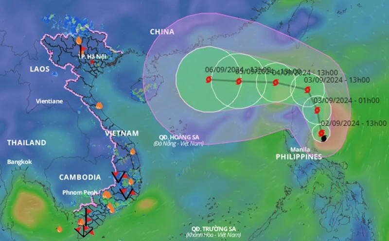
According to a report by the Vietnam Department of Dyke Management and Natural Disaster Prevention, Typhoon Yagi and subsequent floods caused at least VND83.7 trillion (US$3.45 billion) in property damage and left 345 people dead or missing in the country. Yagi is considered one of the most catastrophic natural disasters in Vietnam in decades.
On February 20, 2025, at the 57th annual meeting held in Manila (Philippines), the Typhoon Committee discussed and approved the countries' proposal to remove the name Yagi from the list of international typhoon names.

Returning to the consequences of the recent storm Wipha in Ha Long, many people wonder why, before that, the weather was still hot and sunny, but after only 30 minutes, a tornado created and sank a tourist boat?
There are two main reasons for this: the buildup of heat and high humidity, along with atmospheric instability. As warm, moist air rises, it carries water vapor with it, and when it meets cooler air, it condenses into clouds, causing thunderstorms.
Heat and moisture accumulation:
On hot days, the ground absorbs heat and warms the surrounding air, while the humidity in the air also increases. When this hot, humid air rises and meets the cooler air above, the water vapor condenses into tiny water droplets, forming clouds. This process releases heat, adding to the stuffiness and instability of the air.
Air instability:
As warm, moist air rises and meets cold air, it creates instability in the atmosphere. This instability promotes convection, which causes clouds to grow vigorously, and eventually leads to showers and thunderstorms.
Feeling hot:
When humidity is high, sweat on the body has difficulty evaporating, making us feel hot and uncomfortable.

This is similar to the situation before the rain when the weather is often hot. Associate Professor, Dr. Pham Duc Thi, Center for Hydrometeorology Science and Technology: The two conditions for rain and thunder are high ground temperature and high humidity in the air. High temperature, lots of water vapor and no evaporation make people feel hot and stuffy. The ground heats up, the air and temperature both increase and evaporate.
Only when there is the right humidity, rain and thunder will form. The higher the humid air rises, the more rain clouds will form. Therefore, before the rain, the weather is hot because the air has a lot of water vapor and high temperature. However, not all rains must have this characteristic because it depends on the time of the rain.
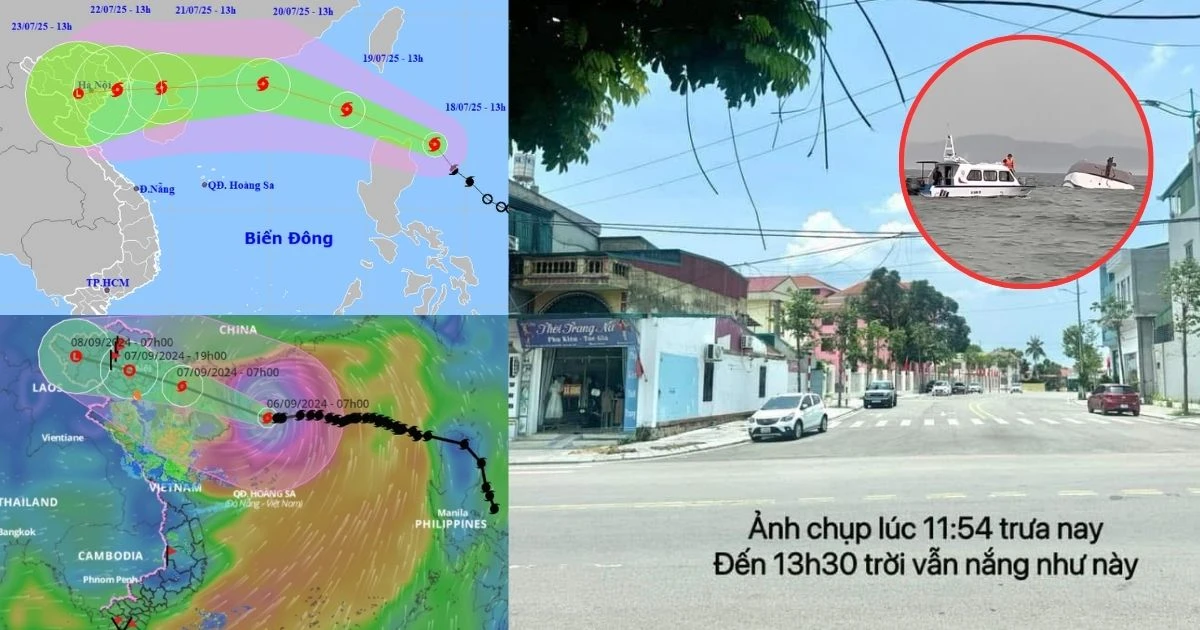
Blue Bay 58 ship capsized in Ha Long: shocking photo revealed, exonerating 'knowing the storm but still going'  Lan Chi13:01:58 20/07/2025Social media is constantly buzzing with the news that a tourist boat carrying passengers to visit Ha Long Bay suddenly encountered a storm and capsized in Gia Luan area (Cat Hai, Quang Ninh), causing dozens of deaths, and 5 people are still missing and have not been found.


 The ship that disappeared in 1913 suddenly appeared, revealing the "mysterious" truth deep under Lake Huron
 Vietnam in the lunar eclipse 'hunting' zone, 102 opportunities to see the beauty of the sky
 The mystery of the dirtiest man in the world, who died just after the first shower
 Empress Dowager Tu Xi suspected that she had 3 lovers, 1 foreigner, who were the other 2?
 Scud-B ballistic missile causes a stir at the September 2nd military parade: Over 34 tons, maximum range 300km
 China: 'Giant straw' pierces from the sky to the ground, revealing a chilling secret!
 Mystery of the Bermuda Triangle: Discovery of "rogue waves", explaining a series of disappearances
 What is MMA that helps a girl defeat a tattooed young man in a split second?
 The secret bedroom of Empress Dowager Cixi, the most powerful but with a debauched love "drama"
1 | 0 Discuss | Report